Riviera Maya Maps
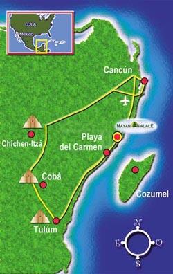
Below are the maps of Riviera Maya and Mexico. Click here if you are looing for Riviera Maya Resort Map
Starting with the basics, you should fly into Cancun for the nearest airport. If you happen to get some phenomenal airfare into Cozumel, you could also do that, take the water ferry to Playa del Carmen and have short 10 minute taxi ride left.
Driving Directions
If you rent from us you will have free shuttle service to the resort, and you can rent a car by the day if you want to. On the other hand, if you opt to rent a car for the week (we usually do), you can rent it at the airport. As you drive out of the airport, you should bear right and follow signs for Playa del Carmen. You have about 20 minutes drive to the resort, it is on the left and will be marked well in advance.
- Drive the speed limit
- Watch for the speed bumps, some of them were moved here from an Olympic ski jump !!
Shuttle Service
We will send you directions on arranging for the free shuttle service to the resort. We suggest waiting for the Monday prior to your arrival to contact the resort. Note: you will have to pay for transportation back to the airport.
Getting Around
If you don't plan a lot of trips "off the reservation" then you can use the shuttles to Playa del Carmen for only $3.50 each way and schedule day excursions with the travel agent on site or use Alltournative.com's website to plan and even book some excursions to Mayan Ruins, Cancun, Xcaret, Xel Ha or cenotes.
Airlines That Fly Into Riviera Maya
- Air Canada
- Air Transat
- American
- Continental
- Delta
- Frontier
- Sun Country
- United
- US Airways
If you need information in Spanish, you can check our pages:
Grand Mayan Riviera Maya en Español
Mayan Palace Riviera Maya en Español